Expedition to Nevado Pissis, the third highest mountain of the andes

Cerro Pissis Expedition (6,793 m)
Remote High-Altitude Mountaineering in Argentina
Overview
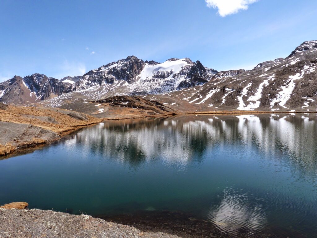
The Cerro (Nevado) Pissis is one of the most impressive yet least visited giants of the Andes. With an elevation of 6,793 metres, it is the third highest mountain in the Andes and the highest volcano entirely located in Argentina. Situated in the remote Cordón de Pissis on the Argentine–Chilean border, this expedition offers extreme altitude, vast solitude and a true expedition character.
Technically the mountain is straightforward, but the altitude, isolation, wind and logistics make this ascent a serious undertaking, suitable only for experienced high-altitude mountaineers.
Location & Geography
Country: Argentina (provinces of La Rioja / Catamarca)
Mountain range: Central Andes – Cordón de Pissis
Type: Stratovolcano
Height: 6,793 m
Region: Ruta de los Seismiles (Route of the Six-Thousanders)
The region is characterised by high-altitude desert landscapes, salt flats, volcanic plateaus and countless 6,000-metre peaks. Despite its enormous height, Cerro Pissis remains rarely climbed due to its remoteness and demanding logistics.
Best Season
Optimal period: January – February
Possible: December – March
Even in summer, strong winds, freezing temperatures and sudden weather changes must be expected.
Expedition Style
Fully self-supported expedition
4WD access to high base camps
Camping in high camps
No huts, no infrastructure, no rescue services on site
Itinerary (Example – 12 to 14 days)
Day 1–2: Arrival in Argentina – Transfer to Fiambalá
Arrival in Buenos Aires, domestic flight to Catamarca or La Rioja, followed by an overland transfer to Fiambalá (approx. 1,500 m). Final equipment check, food organisation and briefing.
Day 3: 4WD Approach – Base Camp
Using 4WD vehicles, we follow remote gravel roads along the Ruta de los Seismiles, reaching a high base camp at approx. 4,600 m.
Day 4: Acclimatisation Day
Short acclimatisation hikes to approx. 4,900–5,000 m, rest and hydration.
Day 5: Ascent to Camp 1
Gradual ascent across volcanic terrain and scree slopes.
Camp 1: approx. 5,200–5,300 m
Day 6: Acclimatisation / Reserve Day
Rest day or optional hike to higher altitude for acclimatisation.
Day 7: Ascent to High Camp
Long but technically easy ascent across wide slopes and plateaus.
High Camp: approx. 5,900–6,000 m
Day 8: Summit Day – Cerro Pissis (6,793 m)
Early start before dawn. The route follows gentle slopes that become steeper near the summit. The main challenges are extreme altitude, cold and wind rather than technical difficulty.
From the summit, spectacular views extend to Ojos del Salado, Tres Cruces and the vast high Andes of Argentina and Chile.
Descent to High Camp or Camp 1 depending on conditions.
Day 9–10: Descent & Return to Fiambalá
Dismantling of camps and return by 4WD to Fiambalá. Optional visit to the local hot springs.
Reserve Days
Additional days are included for weather delays or acclimatisation needs.
Technical Difficulty
Mountaineering grade: F / PD (easy alpine terrain)
No technical climbing
Possible snowfields depending on conditions
Crampons may be required
Required Experience
Prior experience on 6,000-metre peaks strongly recommended
Very good physical condition
Excellent acclimatisation ability
Experience with self-sufficient expeditions
This expedition is not suitable for beginners or as a first high-altitude ascent.
Equipment (Essential)
High-altitude mountaineering boots
Crampons and trekking poles
Expedition sleeping bag (comfort –20 °C)
Four-season tent
Down jacket and full cold-weather clothing
Sunglasses (category 4) and high-SPF sun protection
Helmet (optional, depending on conditions)
Personal first-aid kit
GPS / navigation tools
Satellite communication device (recommended)
Risks & Safety
Acute Mountain Sickness (AMS), HAPE, HACE
Strong winds and sudden weather changes
Extreme dryness and dehydration
Very limited rescue possibilities due to remoteness
A conservative itinerary, careful acclimatisation and professional expedition planning are essential.
Why Cerro Pissis?
Cerro Pissis is not about technical difficulty – it is about scale, altitude and isolation. This expedition offers a rare opportunity to climb one of the world’s highest volcanoes in an environment of absolute solitude, far away from crowded routes.
A true Andean expedition for experienced mountaineers seeking one of the last great quiet giants of South America.
Melting glaciars in bolivian Cordillera Real with the example of 5000er Cerro Wila Manquilizani
Cerro Wila Manquilizani – A Jewel and a Warning in the Melting Ice of the Cordillera Real
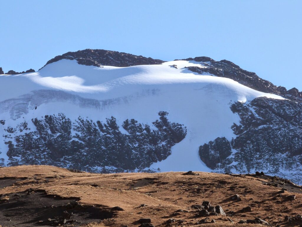
The Cordillera Real in Bolivia is one of the most spectacular mountain ranges of the Andes — a wild landscape of high-alpine peaks, icy slopes and glaciers that, until only a few decades ago, still carried vast ice fields. Among these summits, Cerro Wila Manquilizani, rising to around 5,324 metres, stands out as a rather little-known yet highly attractive mountain north of La Paz. Its steep snow slopes and former ice formations once made it a rewarding objective for mountaineers seeking routes away from the classic peaks. Today, however, climate change has left clear and unmistakable traces here as well.
https://www.suedamerikatours.de/la-paz-tagestouren/cerro-wila-manquilizani
A Mountain in Transition: Character and Ascent
Cerro Wila Manquilizani belongs to those peaks of the Cordillera Real that lie outside the realm of the famous 6,000-metre giants — and it is precisely this fact that makes it attractive to alpinists. Approaches lead through high-Andean terrain, across scree slopes and formerly glaciated flanks that are now, in many places, largely free of ice. Its name and the rarity of ascents give the mountain an exploratory character, as many local mountaineers and international alpinists know it only by reputation.
The Cordillera Real Today – Where Ice Once Ruled
Historically, the Cordillera Real was crowned by numerous glaciers that shaped both the landscape and the regional water balance over thousands of years. Yet the tropical glaciers of the Andes are among the fastest-shrinking ice masses on Earth. Studies show that glacier area in the Cordillera Real has been reduced by around 40 percent or more since the 1980s.
For many individual glaciers, the decline is even more dramatic. Decades of research demonstrate that medium-sized glaciers in the region have continuously lost volume and surface area, a trend that has accelerated since the 1980s. Satellite image analyses suggest that many smaller glaciers below 5,000 metres have almost completely disappeared, while higher-altitude glaciers are shrinking more slowly.
A Victim of Climate Change: Melting Ice Masses
One well-known historical example in the Cordillera Real is the glacier on Chacaltaya, which was used well into the 20th century as the highest ski resort in the world. From an area of approximately 0.22 km² in 1940, the glacier shrank dramatically during the following decades and finally disappeared almost completely by around 2009.
https://www.suedamerikatours.de/bolivien/chachacomani-und-ancohuma-einsame-6000er-in-der-cordillera-real
This fate is symptomatic of the challenges facing the once-powerful ice masses on Wila Manquilizani and neighbouring peaks of the Cordillera Real. Rising temperatures, changing precipitation patterns and increasingly dynamic glacier behaviour driven by global warming are disrupting the long-established balance between accumulation and melt.
cambioclimatico-bolivia.org
The Retreating Ice Wall
Many areas that were once defined by impressive ice walls now reveal bare rock and unstable scree slopes. Where steep, glittering ice faces once dominated the mountain, only remnants of former glaciers remain. Particularly affected are lower glacier tongues and ice walls below about 5,000 metres — precisely those zones of the Cordillera Real that are retreating most rapidly today.
On both small and large scales, this reflects a broader ecological transformation:
Glacial streams swell seasonally, yet deliver less meltwater in the long term.
Permanent ice zones turn into unstable rock and boulder fields.
Alpine ecosystems and the water supply of valleys and cities face growing challenges.
From Summit to a Question of the Future
For mountaineers and nature enthusiasts, Cerro Wila Manquilizani is not merely a destination but also a silent witness to a dramatic climatic process. The story of its ice walls and the transformation of its glaciers reflects the reality of tropical high-mountain regions worldwide: a once ice-crowned range is losing its protective mantle, leaving behind a new landscape of exposed rock and fragile ecosystems. At the same time, this development is closely linked to the fate of the people in the region, who depend on glacier meltwater for drinking water, agriculture and energy.
Outlook
As long as global warming continues, glacier retreat will also progress on mountains such as Wila Manquilizani. Yet these changes can also become places of learning — for alpinists climbing these slopes, for the inhabitants of the Andes who depend on water resources, and for the global community, which can only address climate change collectively.